
Geomorphology Grade 12: Notes, Activities and Questions and Answers
Geomorphology Grade 12: Notes, Activities and Questions and Answers:
Welcome to the ultimate resource page for Grade 12 Geomorphology, where we offer an extensive collection of notes, engaging activities, and comprehensive questions and answers designed to enhance your understanding of geomorphology. This page is your go-to guide for mastering the complexities of the Earth’s surface processes and landforms, tailored specifically for Grade 12 students. Whether you’re seeking to deepen your knowledge or prepare for upcoming exams, our carefully curated materials provide valuable insights and practical tools to support your academic journey in Geomorphology Grade 12.
Geomorphology Grade 12
The Grade 12 Geomorphology curriculum offers a comprehensive exploration into the dynamic earth processes and formations that shape our planet’s surface. This section is designed to provide students with a deep understanding of various geomorphological concepts and the ability to analyze and interpret the physical landscape. Below is an outline of the key topics covered in the Grade 12 Geomorphology section:
Fluvial Geomorphology
- An in-depth look at the processes and landforms created by rivers and streams. Grade 12 Geomorphology delves into how water flow shapes the landscape over time.
Groundwater
- Explores the role of water beneath the Earth’s surface, including aquifers and the processes of infiltration and percolation, crucial components in the Grade 12 Geomorphology curriculum.
Rivers
- Focuses on the characteristics, functions, and importance of rivers in geomorphology. Students in Grade 12 Geomorphology learn about river dynamics and their environmental impact.
Types of Rivers
- Identifies and explains the various classifications of rivers, from perennial to ephemeral, and their significance in the study of Grade 12 Geomorphology.
Drainage Basins
- Covers the fundamental concepts of drainage basins and their role in collecting precipitation, a vital topic in Grade 12 Geomorphology.
Stages of a River
- Outlines the life cycle of a river from youth through maturity to old age, illustrating the evolutionary processes in Grade 12 Geomorphology.
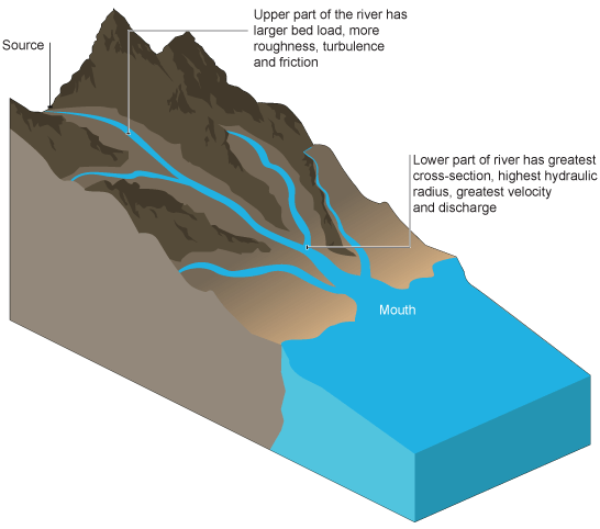
River Profiles
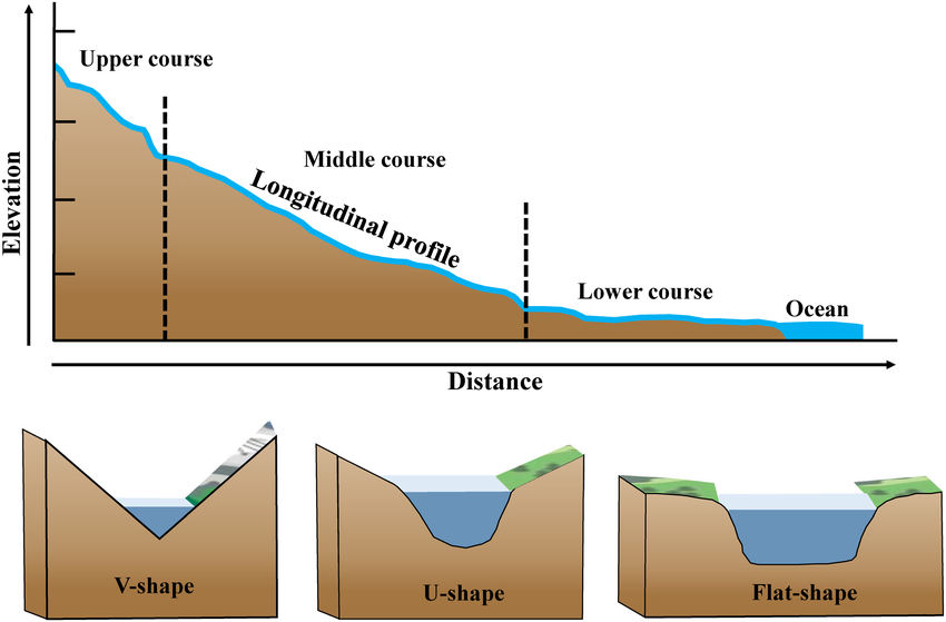
- Examines the longitudinal profile of a river, detailing its gradient from source to mouth, an essential concept in Grade 12 Geomorphology.
River Capture and Rejuvenation
- Discusses the phenomena of river capture and rejuvenation, showcasing the dynamic nature of river systems in the Grade 12 Geomorphology syllabus.
Catchment and River Management
- Addresses the strategies and practices involved in managing river catchments and water resources, emphasizing sustainability and environmental stewardship in Grade 12 Geomorphology.
This overview of the Grade 12 Geomorphology section highlights the curriculum’s dedication to fostering a comprehensive understanding of the earth’s surface processes. Through detailed notes, engaging activities, and targeted questions and answers, students are equipped with the knowledge and skills needed to excel in their studies and appreciate the complexity of the world’s geomorphological features.
Geomorphology Grade 12 Notes
Below are the Geomorphology Grade 12 Notes in pdf format.
Geomorphology Grade 12 Questions and Answers Activities
Grade 12 Geomorphology True or False Quiz Questions and Answers Activity 1
Instructions: For each question, choose the correct answer that best describes the concept based on the fluvial geomorphology key concepts. The correct answers are provided at the end of the quiz to help you assess your knowledge.
Question 1
What does base flow refer to?
A) The seasonal peak flow of a river following rainfall.
B) The consistent flow of groundwater feeding into the river system.
C) The rapid increase in water level due to melting snow.
D) The overflow of a river during flood conditions.
Question 2
The term “base level” is best described as:
A) The starting point of a river at the mountain summit.
B) The elevation at which a river cannot flow uphill.
C) The lowest point to which a river can erode its channel.
D) The average depth of a river measured from the surface.
Question 3
Condensation within the water cycle is the process by which:
A) Liquid water is heated and rises as steam.
B) Water vapour cools down and forms liquid droplets.
C) Ice directly sublimates into water vapour.
D) Water infiltrates deep into the groundwater system.
Question 4
A drainage basin is defined as:
A) A large depression on the land surface that collects rainwater.
B) The confluence where two rivers meet and combine their waters.
C) The entire area drained by a river and its tributaries.
D) A constructed reservoir used for water storage.
Question 5
Erosion involves:
A) The deposition of sediments at the mouth of a river.
B) The process by which a riverbed is deepened and widened.
C) The mechanical breakdown of rocks transported by a glacier.
D) The transport of dissolved minerals by groundwater.
Question 6
Which statement correctly describes a perennial river?
A) It exhibits significant flow only during heavy rainfalls.
B) Its flow is primarily dependent on the seasonal snowmelt.
C) It maintains a continuous flow throughout the year, regardless of season.
D) It ceases to flow during dry seasons, becoming temporarily stagnant.
Question 7
Rejuvenation in a river indicates:
A) The introduction of exotic aquatic species into the ecosystem.
B) A decrease in the river’s sediment load, increasing clarity.
C) The river’s return to a state of increased erosional activity.
D) The artificial alteration of a river’s course for urban development.
Question 8
What are river meanders?
A) Erosional features found on the outer banks of river bends.
B) Underwater ridges formed by the deposition of sediments.
C) Naturally occurring bends or curves along a river’s course.
D) Man-made channels designed to redirect river flow.
Question 9
River discharge is:
A) The legal regulation governing the use of river water.
B) The process by which a river’s water is filtered and purified.
C) The volume of water passing a point within a given time frame.
D) The method used to calculate the depth of a river at various points.
Question 10
Stream capture, or piracy, occurs when:
A) A river adopts new tributaries from a neighboring watershed.
B) Pollution from one stream contaminates another.
C) One river’s course is diverted due to tectonic activity.
D) An upstream river captures the flow from another river.
Answers
- B) The consistent flow of groundwater feeding into the river system.
- C) The lowest point to which a river can erode its channel.
- B) Water vapour cools down and forms liquid droplets.
- C) The entire area drained by a river and its tributaries.
- B) The process by which a riverbed is deepened and widened.
- C) It maintains a continuous flow throughout the year, regardless of season.
- C) The river’s return to a state of increased erosional activity.
- C) Naturally occurring bends or curves along a river’s course.
- C) The volume of water passing a point within a given time frame.
- A) A river adopts new tributaries from a neighboring watershed.
Grade 12 Geomorphology Quiz: Scenario-Based Questions and Answers True or False. Activity 2
Instructions: Read each scenario carefully and choose the correct answer based on your understanding of fluvial geomorphology concepts. These scenarios are designed to test your ability to apply knowledge in practical contexts. Answers are provided at the end of the quiz for self-assessment.
Question 1: River Erosion Scenario
A river in your local area has recently undergone significant changes due to a prolonged rainy season. The banks of the river have become noticeably wider and deeper. This process is most closely associated with which of the following concepts?
A) Deposition B) Erosion C) Condensation D) Percolation
Question 2: Water Cycle Process Scenario
During a field study, you observe water vapor forming droplets on the underside of leaves early in the morning. This process is an example of:
A) Evaporation B) Condensation C) Transpiration D) Infiltration
Question 3: River Feature Formation Scenario
In a study of a local river, you notice a significant bend that has formed over years, creating a wide arc in the river’s path through the floodplain. This feature is best described as a:
A) River meander B) Drainage basin C) River source D) Stream channel
Question 4: Groundwater Flow Scenario
A community relies on wells for their water supply. The consistent level of water in these wells, even during dry periods, is primarily maintained by:
A) Runoff/overland flow B) River discharge C) Base flow D) River/channel flow
Question 5: Fluvial Process in Action Scenario
After a heavy storm, a river’s water level rises rapidly, leading to the overflow of its banks and the deposition of sediments on the floodplain. This event demonstrates the process of:
A) Erosion B) Deposition C) Rejuvenation D) Stream capture
Question 6: Drainage System Scenario
A large area of land is observed to collect and funnel all precipitation through a network of smaller streams that eventually join a major river. This area is best described as a:
A) Watershed/Drainage divide B) River mouth C) Drainage basin D) River meander
Question 7: Water Table Scenario
In a region experiencing a drought, the groundwater level drops significantly, affecting the community’s access to water. This level, below which the ground is saturated, is known as the:
A) Base level B) Water table C) River discharge point D) Condensation level
Answers with Explanations
Question 1: B) Erosion
Explanation: Erosion refers to the process by which soil, rocks, and other surface materials are worn away and transported elsewhere, usually by wind, water, or ice. In this scenario, the river banks becoming wider and deeper due to a prolonged rainy season is a classic example of water erosion. The increased volume and speed of water flow erode the riverbanks and bed, causing them to expand and deepen.
Question 2: B) Condensation
Explanation: Condensation is the process by which water vapor in the air is changed into liquid water. It is responsible for the formation of dew, clouds, and rain. In the scenario, the observation of water droplets forming on the underside of leaves is a result of condensation, where the water vapor cools and turns back into liquid form, collecting as droplets on surfaces.
Question 3: A) River meander
Explanation: A river meander is a natural curve or bend in a river that develops as the river erodes the landscape. Meanders form due to the varying speed of water flow across different parts of the river channel, leading to erosion on the outer banks and deposition on the inner banks. This process gradually creates the distinctive winding paths seen in many rivers, especially in their middle and lower courses.
Question 4: C) Base flow
Explanation: Base flow is the part of a river’s flow that is sustained primarily by groundwater seeping into the river bed. It is crucial for maintaining river levels, especially during dry periods. In the scenario, the consistent water level in wells, even during dry spells, is attributed to the base flow, which represents the ongoing contribution of groundwater to the river system, ensuring a stable water supply for the community.
Question 5: B) Deposition
Explanation: Deposition is the geological process by which sediments, soil, and rocks are added to a landform or land mass. When a river overflows its banks following a heavy storm, as described in the scenario, it loses energy, which reduces its capacity to carry sediment. Consequently, these materials are deposited on the floodplain, enriching the soil and sometimes altering the landscape. This is a vital process for the creation and maintenance of fertile floodplains.
Question 6: C) Drainage basin
Explanation: A drainage basin is the area of land where precipitation collects and drains off into a common outlet, such as a river, bay, or other body of water. It includes both the streams and rivers that convey the water as well as the land surfaces from which water drains into those channels. The scenario describes a typical drainage basin, where water from rain and snowmelt travels through a network of rivers and streams towards a main river.
Question 7: B) Water table
Explanation: The water table is the boundary between the soil surface that is saturated with water and the area where groundwater fills the cracks and spaces in the soil, sand, and rock. It is essentially the top of the groundwater system. In a drought scenario, when the groundwater level drops, the water table also lowers, which can significantly impact water availability for wells and springs, indicating the changing conditions of groundwater storage and flow.